
Earth
India’s Net Zero at Risk: ‘Production Gap Report’ Flags Coal Surge as Climate Betrayal
India’s coal expansion plan clashes with its 2070 net zero pledge, warns the 2025 Production Gap Report, raising risks of stranded assets and climate fallout.

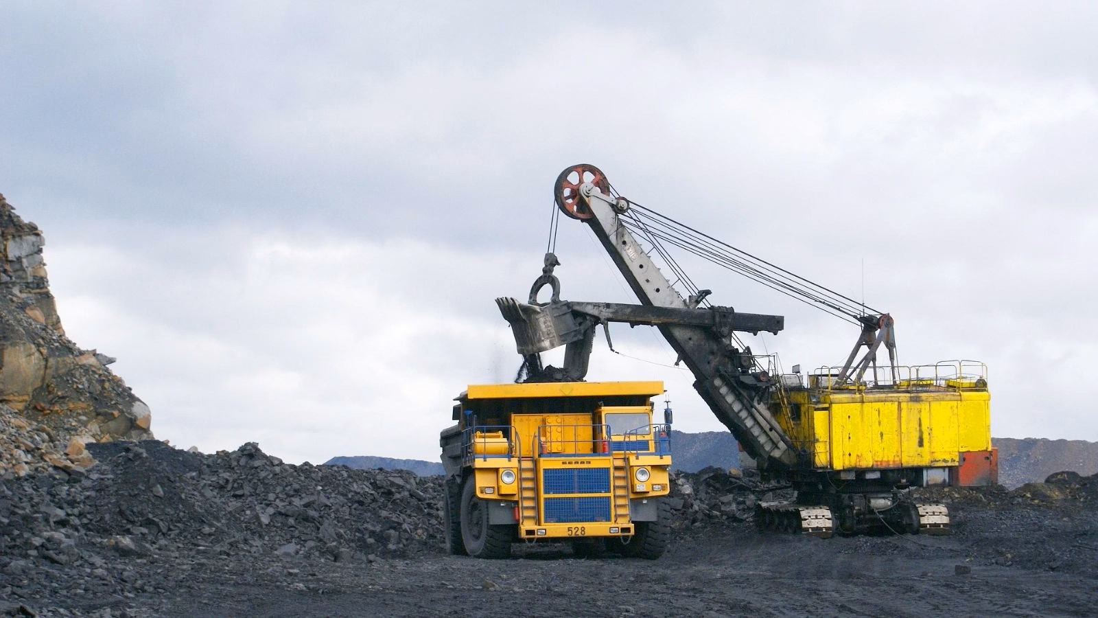
India today sits at the heart of the global climate debate. With more than 1.4 billion citizens and surging energy demand, it is both a vital growth engine and a critical player in the global clean-energy transition. The government has legally enshrined a commitment to reach net zero emissions by 2070, a pledge at the COP26 climate summit in Glasgow, in 2021, and welcomed as a landmark step. Yet the newly released Production Gap Report 2025 underscores a troubling contradiction: India is simultaneously planning a sharp increase in coal production, a trajectory that risks undermining its own climate promises and the world’s fight to limit warming to 1.5°C.
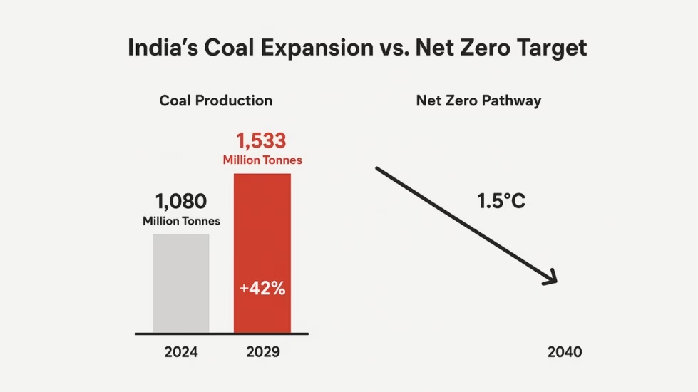
According to the report, New Delhi aims to raise annual coal output to 1,533 million tonnes by 2029—an increase of 42% over 2024 levels. This expansion comes even as scientists stress that global coal use must peak and begin declining rapidly this decade, with near-total phase-out by 2040, to meet Paris Agreement goals. The report puts it bluntly: “Every year of delay will only increase the challenges and costs of future decarbonization.”
Energy Security vs. Climate Action
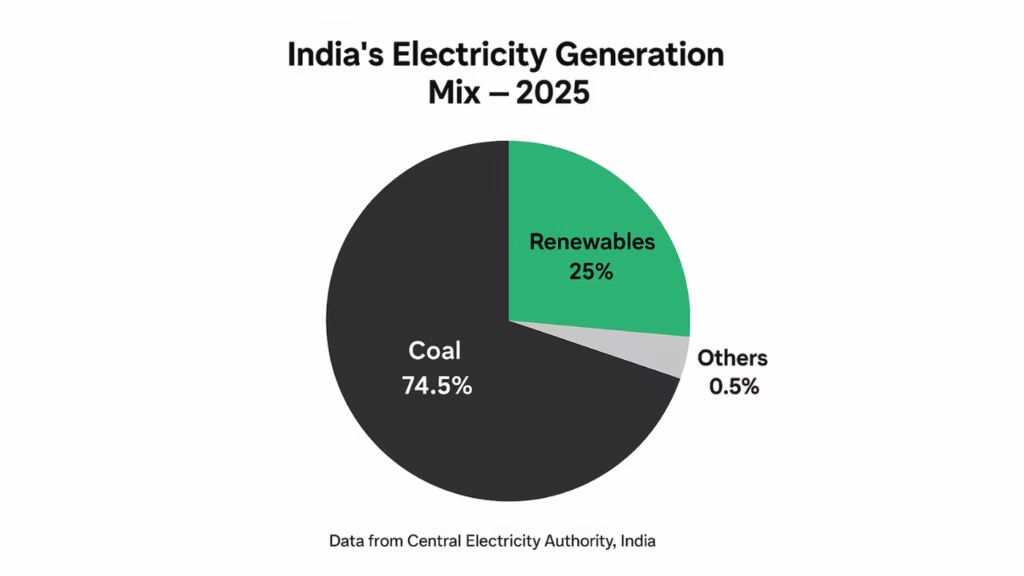
Why, then, is coal still central to India’s strategy? Policymakers argue that coal remains indispensable for three intertwined reasons: economic growth, affordable power for millions still climbing the development ladder, and jobs in coal-rich states like Odisha, Jharkhand, and Chhattisgarh. Coal still supplies about 55% of India’s total primary energy, and fuels nearly three-quarters of electricity generation. The government’s Revised SHAKTI (Scheme for Harnessing and Allocating Koyla (Coal) Transparently in India) Policy (2025), unveiled in July, reinforces this trajectory by making coal allocation more transparent and competitive, aimed at “promoting affordable power and seamless thermal capacity addition for economic growth,” as the Coal Ministry put it.
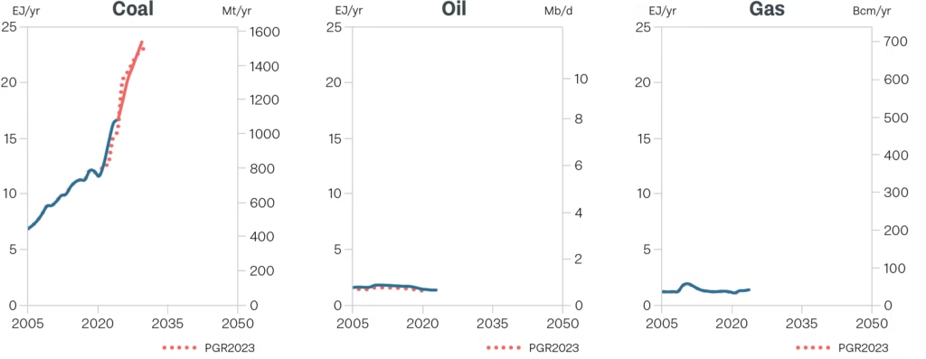
For many within India’s policy establishment, this is not a choice but a necessity. With energy demand projected to double by 2040, and global oil and gas markets increasingly volatile, domestic coal offers a sense of energy sovereignty. Stockpiles at power plants recently touched record highs, enough for 25 days of consumption, a buffer the government celebrated as proof of its robust energy security planning.
The Costs of Persistence
But the other side of the ledger is stark. The Production Gap Report warns that India’s continued coal expansion is fundamentally misaligned with climate science. Global Energy Monitor estimates that many existing coal mines already run below capacity, at only around 64% utilization. Opening new mines risks locking the country into a fossil-fuel path that could soon become economically unviable as renewable energy grows cheaper and more scalable. Analysts caution that billions of dollars in new coal investments could become stranded assets within two decades.
The social costs are equally significant. Tribal and rural communities in mining belts face displacement, loss of livelihoods, and worsening air and water quality. Without a robust “just transition” plan, the burden of India’s coal reliance may fall disproportionately on its most vulnerable citizens.
A Parallel Green Surge
Yet India is also writing another story—one of remarkable clean-energy progress. Over the past decade, solar capacity has expanded nearly forty-fold. Wind, bio-energy, and small hydro continue to grow, supported by policies such as the PM Surya Ghar Yojana and PM Kusum Yojana, which subsidize rooftop solar and farmer-oriented renewable projects. In 2025, the government slashed the GST (Goods and Services Tax) on renewable energy equipment from 12% to 5%, a move projected to save developers $16.9 billion (INR 1.5 lakh crore) by 2030, lowering tariffs and making clean power more accessible.
The numbers reflect this momentum. In the first half of 2025, India’s renewable power generation rose by nearly 25% year-on-year, while the share of fossil fuel-based electricity slipped to below 78%—its lowest in recent years. The Ministry of New and Renewable Energy projects 248 GW of new non-fossil capacity over the next five years, putting the country on track toward its ambitious 500 GW clean-power target by 2030.
A Decisive Decade
The contradiction is clear: India is simultaneously expanding its coal base and accelerating into the clean-energy future. This dual track reflects the country’s developmental realities, but it also sharpens the urgency of the choices ahead. Without clear timelines for peaking and phasing down coal, the net zero pledge of 2070 risks looking increasingly fragile.
The answer, experts argue, lies not in choosing coal or clean energy in isolation, but in crafting a comprehensive strategy: ensuring coal-dependent states receive support for economic diversification, investing in grid modernization and storage to handle more renewables, and phasing out inefficient coal plants while stopping new approvals. Done right, India could avoid both the trap of stranded assets and the perils of climate inaction.
As the Production Gap Report 2025 makes clear, the coming decade will be decisive. For India, the crossroads is stark: persist with a coal-heavy pathway that offers near-term comfort but long-term risk, or accelerate a transition that secures both its development aspirations and its place as a climate leader. The world is watching closely, but more importantly, India’s own future prosperity may hinge on the choices it makes today.







Climate
When the Himalayas Collapse Without Warning, What Counts as Preparedness?
Nepal flash floods show why Himalayan disaster preparedness must go beyond early warnings to safer infrastructure, land-use planning and climate adaptation.

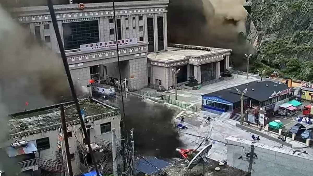
The Rasuwa disaster (Nepal flash floods) has killed more than 1,000 people in Nepal and China and left thousands missing. The catastrophe exposes a harder problem than the absence of an alarm: how do you protect communities and infrastructure when mountain hazards can cascade within minutes?
On the morning of August 26, a mass of ice and rock broke loose high in Nepal’s Rasuwa district and plunged roughly 1,200 metres into the valley below. Within minutes, the resulting debris and water surged into the Bhotekoshi River system.
A week later, the scale of the disaster is far clearer and far more devastating than initial reports suggested. Nepal’s National Disaster Risk Reduction and Management Authority (NDRRMA) has reported 1,050 deaths and 3,916 people missing. China has reported another 16 deaths and 546 missing in the affected area across the border, taking the combined death toll to 1,066. More than 11,800 people have been rescued in Nepal, but the search continues in remote valleys and at damaged hydropower projects. The numbers continue to shift as rescue teams recover bodies and families search for missing relatives.
Nepal flash floods expose the limits of early warning
Researchers analyzing satellite imagery, seismic signals, and video footage say the flood was likely triggered by an ice-rock avalanche rather than a conventional glacial lake outburst flood (GLOF). The distinction matters: while a glacial lake’s water levels and drainage systems can be monitored for early warnings, an unstable mountain slope can fail suddenly, turning a quiet landscape into a debris corridor within minutes.
A disaster that outran the warning system
ICIMOD’s assessment notes that the collapse occurred around 8:37 am Nepal Standard Time, producing a magnitude 5.2 seismic signal. Hydrological data shows how rapidly the event unfolded: water levels on the Trishuli River at Galchchi rose nine metres in just 30 minutes, while levels at Malekhu rose seven metres in a similar window, washing away several monitoring stations in the process.
This highlights a hard reality in disaster management: a warning system is only useful if there is enough lead time to act.
Dr. Farooq Azam, Senior Cryosphere Specialist at ICIMOD, described the Rasuwa event as a sudden-onset hazard with no detection and no time for warnings. Because deep-seated bedrock or sub-glacial instabilities remain invisible to standard surveillance, identifying a failure point in advance is rarely possible. The take-away isn’t that early-warning systems are useless, but rather that they cannot be the sole pillars of Himalayan safety.
From early warning to early preparedness
When casualties run into the thousands, the scope of the problem extends far beyond simple flood management. Nearly 1.6 million people have been affected across a broad area, with extensive destruction to roads, bridges, markets, communications, and power grids. As of September 1, NDRRMA figures show at least 639 hydropower workers missing, while over 21,000 security personnel remain deployed for search and rescue.
When a sudden mountain hazard strikes, built infrastructure often compounds the catastrophe. Destroyed roads delay emergency crews, collapsed bridges isolate entire villages, damaged power plants force dangerous confined-space rescues, and lost monitoring stations blind teams downstream.
Because of this, Azam advocates shifting focus toward long-term resilience: stricter land-use planning, safer infrastructure siting, and public awareness of high-altitude risks. He emphasizes that environmental impact assessments must evaluate how a shifting mountain landscape will affect a project over its entire operational lifetime—not just during construction. Planners can no longer just ask if a bridge or power plant can survive today’s weather; they have to design for conditions 30, 50, or 70 years down the line.
The Himalayas are not a static landscape
While current scientific evidence does not draw a direct line from climate change to this single avalanche, the event occurred within a mountain ecosystem experiencing rapid physical changes.
Glaciological assessments show accelerating mass loss across the Himalayas, with negative mass balance recorded in 89% of observed years over the last five decades. The Hindu Kush Himalaya region has also seen significant 21st-century warming, rising between 0.15°C and 0.60°C per decade.
These shifts ripple through the whole ecosystem. Snow cover patterns are shifting, permafrost is thawing, and slope stability is deteriorating. Thawing permafrost is particularly concerning high up, where frozen ground acts as a natural glue; as it thaws, erosion, landslides, and slope failure increase, directly threatening down-valley infrastructure. Climate change doesn’t need to directly trigger an avalanche to make the entire region significantly more fragile.
Black carbon is another pressure on the cryosphere
Particulate pollution presents another major stressor. A study by Climate Trends found that black carbon concentrations on the Indian side of the Himalayas rose by roughly 7.74% between 2000–09 and 2010–19. The study recorded a notable jump in average snow-surface temperatures, which rose from -11.27°C (2000–09) to -7.13°C (2020–23).
Black carbon darkens snow, reducing its reflectivity and accelerating surface melting. Because mountain ice acts as a natural water reservoir for downstream populations, this melting threatens long-term water security. While black carbon didn’t explicitly cause the Rasuwa slide, it underscores why regional environmental risks must be tackled holistically rather than in isolated hazard buckets.
The problem begins with where we build
Ultimately, the hardest questions around Rasuwa are geographical: Where are we building towns, laying roads, and placing power plants?
Over recent decades, infrastructure has steadily encroached onto lower riverbanks and active floodplains. While older communities historically built on higher ground to avoid active river channels, modern land-use planning frequently ignores these natural boundaries. Bringing local and indigenous geographical knowledge back into modern engineering decisions is a practical starting point for adaptation.
Anjal Prakash, Professor of Public Policy at FLAME University and an IPCC author, points out that the region does not suffer from a lack of science. Researchers have tracked retreating glaciers, changing permafrost, and rising snowlines for decades. The failure, he argues, lies in policy— translating well-documented risks into smarter zoning and construction choices.
A regional disaster cannot be managed country by country
The Rasuwa crisis also demonstrates why disaster planning cannot stop at national borders. The affected river systems cross international boundaries, the failure originated near the Nepal-China border, and the resulting debris washed through multiple downstream jurisdictions.
The World Meteorological Organization points to this as a clear example of cascading transboundary hazards. Aarti Khosla, Director of Climate Trends, similarly notes that risks across the Hindu Kush Himalaya affect India and neighboring countries equally, requiring joint approaches to monitoring, early warning, and climate adaptation.
Data sharing across borders is essential. A flood warning downstream in one country often relies on sensor data from upstream in another. When development choices or infrastructure failures in one nation can trigger impacts across the border, regional coordination becomes a necessity rather than an option.
The future risk is not just more floods
Disaster risk in the Himalayas is often oversimplified into a single concept: Glacial Lake Outburst Floods (GLOFs).
GLOFs are a major threat, but the vocabulary needs to expand. The mountains face ice falls, rockslides, landslide-dammed rivers, debris flows, and slope failures—often interacting all at once. An avalanche blocks a river; the temporary dam holds back water until it breaches; the resulting torrent sweeps up massive amounts of rock and earth; the debris wipes out bridges and monitoring equipment, leaving downstream teams blind to what is coming next. Preparing for mountain hazards means preparing for these linked multi-stage events, not just isolated floods.
What preparedness should look like now
A practical response requires pairing early-warning technology with long-term climate adaptation:
- Diversify warning networks: Expand river sensors, satellite tracking, and local alert channels where lead time exists, while planning for events that offer no notice at all.
- Update zoning and land use: Base building regulations on dynamic river and slope modeling rather than static historical maps.
- Mandate life-cycle risk assessments: Require infrastructure projects to factor in climate and cryosphere projections over their entire intended lifespan.
- Build system redundancy: Ensure communications, transit routes, and monitoring stations have backups so a single failure point doesn’t collapse an entire emergency response.
- Integrate local knowledge: Use community insights on historical floods and terrain stability alongside satellite and scientific data.
- Formalize transboundary cooperation: Share real-time hydrological, seismic, and weather data across international borders.
The mountains are changing. Policy must catch up.
The long-term outlook for the region is stark. Under high-emissions scenarios, Himalayan glaciers could lose over 60% of their volume by 2100; even moderate scenarios project losses of up to 35%.
These projections outline a fundamental transformation of the mountain environment. Glacial retreat initially leads to periods of higher runoff—”peak water”—followed by declining long-term water availability, directly impacting farming, drinking water, and energy production across South Asia.
As UN Climate Change Executive Secretary Simon Stiell has noted, rising temperatures are making severe mountain disasters more frequent. In the Himalayas, the core issue is that expanding human settlements and multi-million-dollar infrastructure projects are sitting in the path of a rapidly changing landscape designed around historical climate assumptions.
When a mountain moves without warning, safety relies entirely on decisions made years or decades before the collapse happens.
Earth
Scientists Map Earth’s Sand Dunes in a New Global Survey
A new global map of Earth’s sand dunes is giving scientists a clearer picture of how wind, sediment and climate interact to shape dry landscapes. The dataset could also help researchers interpret ancient climates on Earth and dune patterns on Mars.
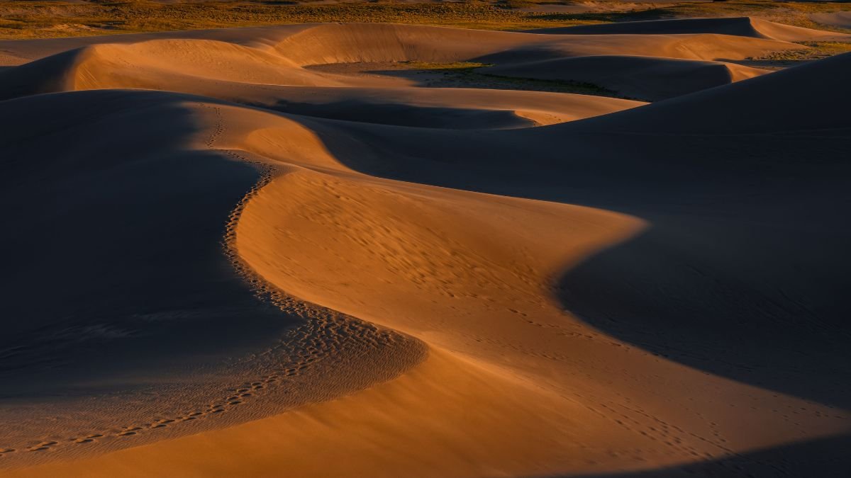
Scientists have mapped the distribution of Earth’s wind-blown sand dunes at a global scale, providing a new way to study how sediment, wind and climate shape some of the planet’s driest landscapes. A sand dune is a hill or ridge of loose sand that has been formed and shaped by the wind. Dunes are commonly found in deserts and along beaches, wherever there is plenty of loose sand and enough wind to move it. Sand dunes are mainly classified into barchan (crescent-shaped), linear, star, parabolic, and transverse dunes, based on their shape and wind patterns.
The study, published in Nature Communications, finds that dune formation cannot be explained by aridity or wind speed alone. In dry regions, dunes are strongly associated with the movement of sediment towards areas where it accumulates. In wetter regions, stronger winds are needed to move enough sand to overcome the effects of vegetation and other surface conditions.
Andrew Gunn, a researcher at Monash University’s School of Earth, Atmosphere and Environment, built the map using globally available satellite imagery and topographic data. The resulting dataset identifies dunes across Earth’s continents and distinguishes their different forms.
The map covers dunes detected across about 7.8% of Earth’s surface. Their distribution is concentrated largely in the lower mid-latitudes, although the study found that the presence of dunes depends on a combination of sediment supply and the way wind transports that material.

Wind is Only Part of the Story
A desert may have strong winds and still lack dunes.
That is because wind needs loose sediment to move. The study found that in arid landscapes, the location of a dune field is closely tied to the availability and movement of sediment. Where material is supplied from several directions and transported towards the same area, sand can accumulate and produce dunes.
The picture changes in places with more rainfall. Vegetation and surface moisture can hold sediment in place, meaning winds need to be stronger before enough sand starts moving to build dunes.
The distinction matters when scientists use dunes as evidence of past environments. A dune’s shape and orientation can preserve information about the winds that formed it, but those features can also reflect the source and movement of the sand itself.
The researchers demonstrated this using barchan dunes, the crescent-shaped formations commonly found in areas where winds blow predominantly in one direction. Their orientation can provide information about wind direction, while their arrangement can also reveal something about sediment transport.
A Reference Point for Past Climates
Dunes can outlast the conditions that created them. Their position and form can therefore provide clues about earlier wind regimes, sediment movement and climate, particularly in places where direct observations do not exist. The new dataset gives researchers a consistent global reference rather than requiring them to compare separate regional maps made using different methods. That could be useful for studies of how dry landscapes have changed over time and how wind-driven erosion may respond to shifts in climate.
The map also has a planetary application. Mars has extensive dune fields, but scientists cannot measure its surface winds with anything close to the coverage available on Earth. Dune forms are therefore among the clues used to reconstruct Martian surface conditions.
The Earth dataset does not provide a direct translation from one planet to the other. Instead, it gives researchers a better understanding of how particular dune shapes relate to wind and sediment on Earth, which can inform interpretations of similar landforms on Mars.
The study’s value gives scientists a common dataset for asking why dunes occur where they do — and what their patterns can tell us about the landscapes that produced them.
Climate
Record Drought and Extreme Heat Push European Rivers to Lows as Wildfires Spread North
The European drought is driving rivers to record lows as extreme heat, wildfires, crop losses and water shortages put Europe’s energy and transport systems under pressure.

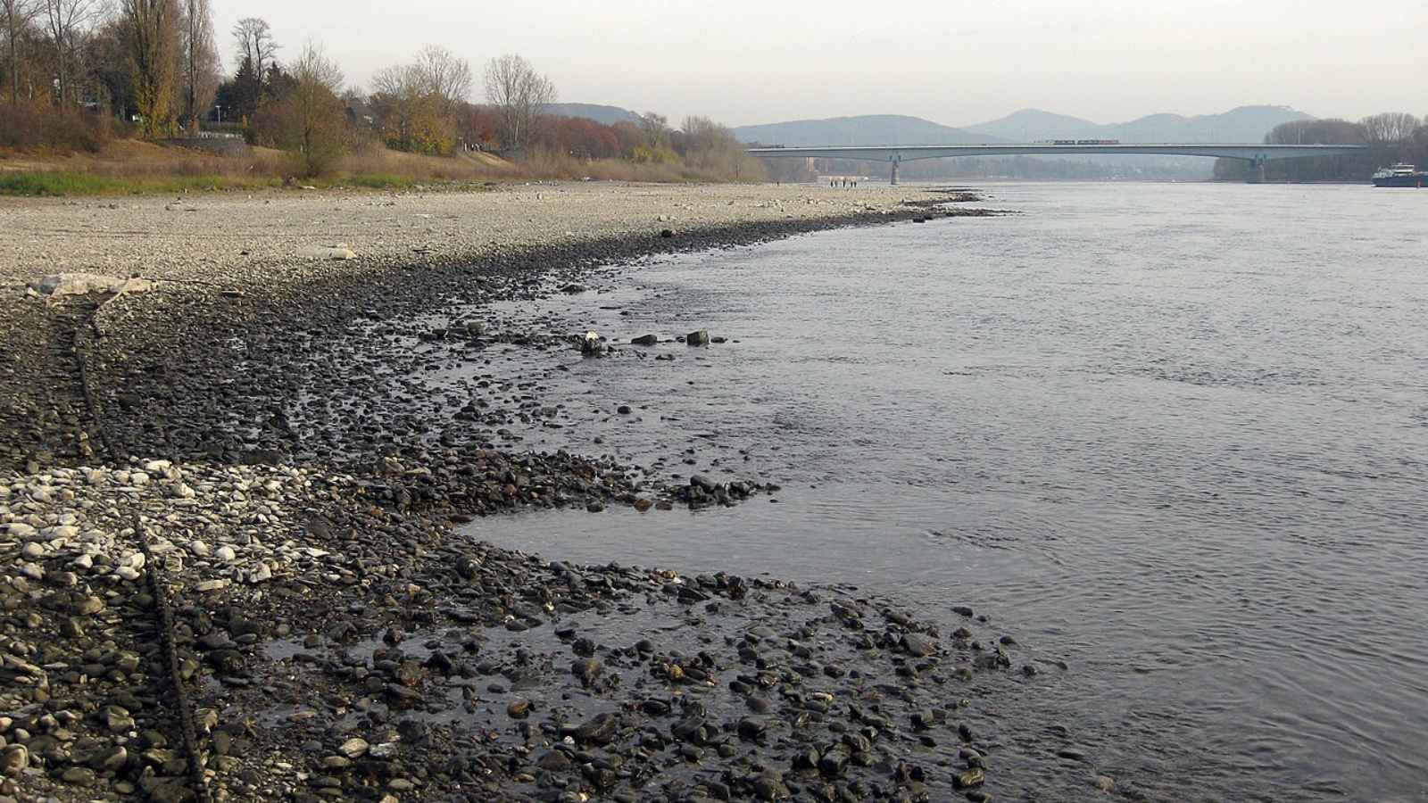
A prolonged European drought combined with extreme heat is pushing major rivers to record lows, disrupting shipping and energy production while worsening crop losses and wildfire risks. As dry conditions spread north, Europe’s water, agriculture, ecosystems and public health systems are coming under increasing pressure.
A long period of low rainfall combined with extreme heatwaves has placed half of the European Union and the United Kingdom under drought conditions. A report published on August 12 by the European Commission Joint Research Centre and the European Drought Observatory reveals that nine percent of the region reached a critical alert level by late July.
Satellite data from Copernicus, the Earth monitoring program of the European Union, shows that severely dry soil is now damaging crops and plants across the continent. In its latest assessment, the observatory warned that “the drought has built up since early spring due to lower rainfall and higher than average temperatures, turning into fuel for devastating wildfires.”
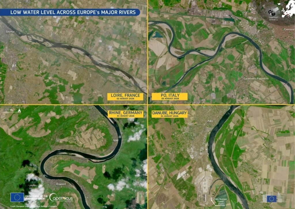
European Drought Reaches Across the Continent
The lack of rain has driven four of Europe’s largest rivers—the Rhine, Danube, Loire, and Po—to dangerously low levels. Near Cologne, Germany, the Rhine fell to a fresh record low of 49 centimetres by mid-August, according to the Rhine Waterways and Shipping Authority — nearly 20 centimetres below the previous record of 68 centimetres set earlier in the summer, which had itself broken the prior all-time low recorded in 2018. Because large cargo boats need deeper water to float safely, operators have been forced to carry much lighter loads to avoid getting stuck on the riverbed, and in places river traffic has largely halted. Carrying smaller loads requires more trips, creating major shipping delays for important industrial materials across central Europe.
At the same time, low water levels and rising temperatures are creating a serious energy crisis across the continent. In France, power companies had to cut back nuclear energy production because river water became too warm to safely cool reactors without harming aquatic life. Hydroelectric power generation has also plunged across the Alps, northern Italy, and central-eastern Europe. Copernicus analysts noted that low river flows on the Danube are creating “serious operational challenges” for power plant cooling. In Italy’s Po Valley, the dried-out river basin has triggered a separate disaster: saltwater from the Adriatic Sea has flowed inland into depleted channels, ruining farmland soil and cutting off freshwater supplies for local crops.
Wildfires Burn Over 550,000 Hectares Across Europe
Dry plants and extreme heat have triggered widespread wildfires across the continent. According to August 11 data from the European Forest Fire Information System, 552,437 hectares of land have burned within the European Union since the start of the year, spread across 1,614 individual fires of 30 hectares or larger. Although this total remains below the 667,342 hectares burned by the same date in 2025 — a season that went on to become the worst on record for EU wildfires, with 1,034,552 hectares burned in total — it is significantly higher than the 20-year historical average.
Recent satellite data shows a clear shift: large wildfires are no longer staying just in southern hotspots like Spain and Greece. As dry weather pushes northward, fire risks are expanding into cooler regions, including northwestern France, southern Great Britain, the Alps, and the Balkans. Experts at the Joint Research Centre emphasized that “wildfire risk is no longer confined to southern Europe but is increasingly affecting wider parts of the continent under prolonged hot and dry conditions.”
Declining Harvests and Rising Health Risks
Continued heat and dry soil are dealing a heavy blow to European farmers. According to assessments by the European Joint Research Centre, crop yields across central and eastern Europe have dropped significantly. Production estimates for key spring and summer crops, such as grain maize and sunflowers, have fallen by six to seven percent. Winter crops have also suffered, with yield forecasts declining between one and four percent compared to earlier projections.
High temperatures are having a severe impact on human health as well. Monitoring data from public health agencies and the World Health Organization reveals a sharp surge in heat-related emergency admissions and deaths during extreme temperature episodes. Data compiled from national health agencies — including Germany’s Robert Koch Institute, which alone recorded an estimated 11,900 heat-linked deaths — put the region’s heat-related death toll above 25,000 as of early August, highlighting the severe human cost of this summer’s weather.
Seasonal Outlook and Emergency Response
Weather predictions indicate that dry conditions will continue through early autumn. According to the Copernicus Climate Change Service, drier and warmer weather is expected to persist across central-western Europe and southern Scandinavia through September. Climate experts also warn that a developing El Nino pattern could keep global temperatures higher than normal well into spring 2027. “Water resources, crops, energy systems, river transport, and ecosystems are all under growing pressure,” the report warned, with heatwave risks remaining high through August.
To coordinate emergency aid, the European Union activated its Civil Protection Mechanism. A dedicated fleet of 22 firefighting aircraft, 5 helicopters, and ground teams have been placed on standby across 12 countries. Meanwhile, the Copernicus satellite service has responded to more than 30 emergency requests since June, providing real-time mapping data to help local authorities track active fires and assess land damage on the ground.


India’s Investment Growth Has Doubled. Is Private Capital Finally Moving?

Anxiety Freezes Career Decisions. Curiosity Unfreezes Them

The Engineer of Tomorrow Is Already Here

The AI That Helps Humans See When Self-Driving Cars Go Wrong

India Is Facing More Climate Disasters. Who Pays When They Happen?

Astronomers Discover a ‘Black Hole Star’, a New Kind of Object in the Early Universe

From Bell Labs to the Classroom: Finding Purpose After Retirement

From Soil to Profit: How Organic Turmeric Changed the Fortunes of a Tribal Farming Family

Farmers Borrowed to Build ‘Diggis’. Two Years Later, They Are Still Waiting for the Subsidy

Our Algorithm Knows What We Want Before We Do. That is the Problem.

-

 Math1 month ago
The 2026 Fields Medals: Four Proofs, Four Decades-Old Problems Solved
-
Climate1 month ago
After Kerala’s Deadliest Landslide, the Hardest Thing to Rebuild Was Childhood
-
Society2 months ago
West Asia Crisis: Can Kerala’s Returning Gulf Migrants Find a Future in the Green Economy?
-
Space & Physics3 months ago
India Semiconductor Mission: ‘It’s Not About Fabs. It’s About Building An Entire Ecosystem’
-
Climate3 months ago
The Climate World Cup? How Climate Change Could Affect Player Performance at the 2026 World Cup
-
Society2 months ago
What Is Civilisational Diplomacy? Understanding India’s Newest Foreign Policy Tool
-
Society3 months ago
From Bell Labs to the Classroom: A Second Career in Teaching
-
Space & Physics3 months ago
Engineers Develop Dual-Mode Propulsion System for Next-Generation Small Satellites