
Climate
Nepal’s Glacier Disaster Exposes the Unequal Cost of Climate Change
Nepal contributes only about 0.1% of global greenhouse-gas emissions, yet its communities face growing risks from glacier loss, floods and landslides. The latest glacier-related disaster shows how climate vulnerability can fall hardest on countries that have contributed little to global warming.

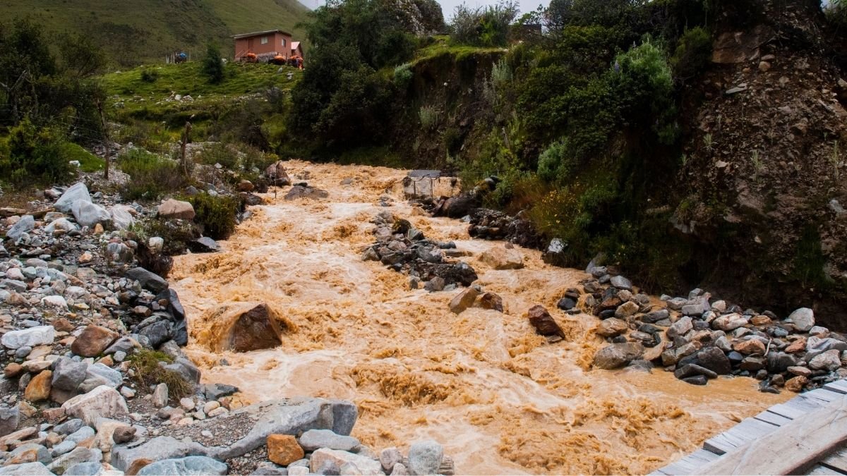
A glacier collapse in Nepal has set off a chain of floods and landslides along the country’s border with China, killing hundreds of people and leaving thousands missing. Roads and bridges have been swept away, hydropower facilities damaged and a key trade route disrupted. The disaster has also brought an uncomfortable question to the surface. Nepal has contributed very little to the greenhouse-gas emissions driving global warming. Yet the country’s mountains are among the places where a changing climate is being felt most sharply.
Nepal’s disaster authorities said on August 29 that 626 people had died and 2,426 remained missing after the floods on August 26. China has reported seven deaths and hundreds of people missing in Tibet. Bad weather has slowed helicopter operations, while damaged roads and other infrastructure have made it difficult for rescuers to reach some areas.
The disaster began high in the mountains, where a large section of glacier broke away, sending ice, rock and debris into the river system below. The resulting surge tore through valleys in Nepal and Tibet, damaging homes, roads, bridges and other infrastructure. Scientists are still working to establish exactly what caused the glacier to collapse.
That uncertainty is important. There is not enough evidence to say that climate change caused this particular event. But the collapse happened in a Himalayan region that is warming rapidly and losing ice at an accelerating rate.
A Country that Emits Little
Nepal’s share of global greenhouse-gas emissions is about less than 0.1%, according to the World Bank. That is a small contribution when compared with the major economies whose industries, transport systems and energy use account for much larger shares of global emissions. Nepal’s economy has not been built around the kind of large fossil-fuel industries that have driven emissions in many wealthier countries.
Yet geography leaves Nepal unusually exposed. Much of the country lies in the Himalayas, where communities live below steep slopes, glaciers and rivers. Floods, landslides, drought and glacial lake outbursts already pose serious risks. When a hazard begins high in the mountains, its effects can travel quickly into valleys where people live and where roads, hydropower projects and other infrastructure are concentrated.
For Nepal, the problem is therefore not simply how much carbon it emits. It is how much damage it can absorb when the climate and its mountain environment change.
The Himalayas are Changing
The August disaster comes as Nepal’s glaciers undergo a profound transformation. The country’s glaciers have lost nearly one-third of their ice in just over three decades, according to estimates cited by the United Nations. The pace of ice loss in the decade before 2023 was about 65% faster than during the previous decade.
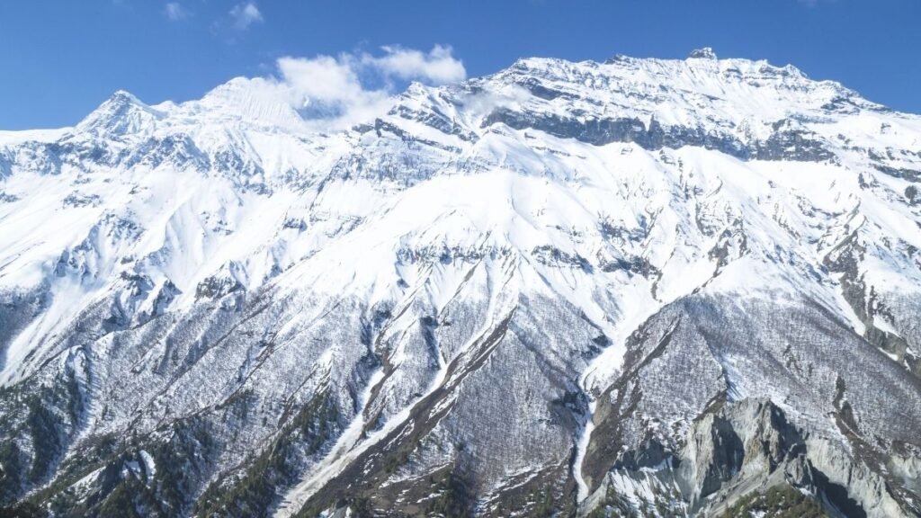
As temperatures rise, glaciers retreat and snow and ice patterns change. Mountain slopes can become less stable, while melting ice and changing water flows can alter the risks faced by communities downstream. The danger is not limited to one type of event. A collapse high on a mountain can trigger an avalanche or debris flow, which can block a river, create a temporary lake and set up another flood further downstream.
That sequence is now playing out in the aftermath of the August 26 disaster. The force of the flood damaged infrastructure and changed parts of the river system. New blockages and lakes have also raised concerns about further flooding. For people living in these valleys, the danger does not necessarily end when the first flood passes. Damaged roads can cut off communities from food and medical care. Disrupted water and sanitation systems can create additional health risks. And rebuilding can take months or years.
When Disaster Meets Poverty
Climate risk becomes harder to manage when a country has limited resources to prepare for it. The World Bank estimates that climate impacts could leave Nepal’s economy at least 7% smaller by 2050 if climate risks are not adequately addressed. Floods, landslides, drought and water stress already threaten livelihoods and infrastructure.
The latest disaster shows what those risks look like on the ground. More than 90,000 people need urgent assistance, while UNICEF estimates that about 17,000 children require humanitarian support. Eighteen schools have been destroyed and another 20 damaged. Entire communities have been swept away, leaving survivors in need of shelter and basic supplies.
The damage is also hitting infrastructure that Nepal depends on for its economy. Hydropower plants, roads and the border crossing with China have been affected, disrupting electricity generation, transport and trade. For a country still working to expand access to basic services and economic opportunities, a disaster of this scale creates a difficult trade-off. Money that could have gone towards schools, healthcare, roads or jobs may instead have to be spent repairing what has been destroyed.
The Cost of a Crisis Nepal did Little to Create
Nepal has committed to reaching net-zero emissions by 2045 and sees hydropower as an important part of its development. But Nepal becoming a lower-emissions economy will not, by itself, stop glaciers from retreating or prevent hazards in the Himalayas. The drivers of global warming extend far beyond Nepal’s borders. That makes adaptation critical. Better early-warning systems can give communities more time to move out of harm’s way. Monitoring glaciers and glacial lakes can help identify dangerous changes before they become disasters. Stronger roads, bridges, schools and health facilities can reduce the damage when extreme events occur.
All of this requires money, something that countries with small economies and limited fiscal space do not always have in sufficient amounts. The August disaster does not prove that climate change caused the glacier collapse. But it has occurred against a clear backdrop of rising temperatures and rapid ice loss in the Himalayas.
Nepal’s predicament is therefore larger than this one disaster. The country has contributed only a small amount to the greenhouse gases accumulating in the atmosphere, yet its communities are being asked to cope with a landscape that is becoming harder to predict. The people living beneath the Himalayas did not build the global carbon economy. But they are increasingly having to deal with what it has left behind.
That is where the climate debate becomes tangible, not in emissions charts alone, but in the homes, schools, roads and livelihoods that can disappear when a mountain gives way.








Climate
Cyclone Arnab Makes Landfall in Andhra Pradesh, Uproots Trees and Disrupts Power Supply
Cyclone Arnab hits Andhra Pradesh with strong winds and heavy rainfall, disrupting transport and electricity supply as authorities evacuate vulnerable coastal communities.
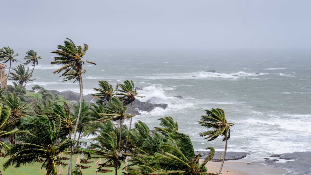
Cyclone Arnab crossed the Andhra Pradesh coast in the early hours of Wednesday, October 28, bringing destructive winds and heavy rainfall to coastal districts. Trees were uprooted, electricity infrastructure was damaged and transport services were disrupted as authorities continued emergency operations in vulnerable areas. The last major cyclone to hit Andhra Pradesh before Cyclone Arnab was Cyclone Montha, which made landfall near Kakinada on October 28–29, 2025. It struck almost exactly a year before Arnab’s landfall on October 28, 2026.
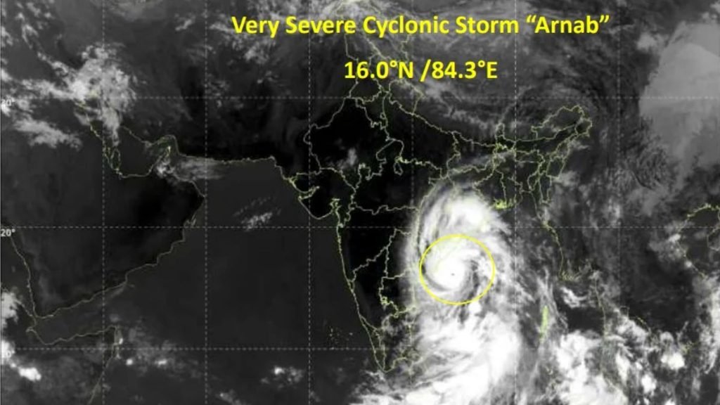
The India Meteorological Department (IMD) had forecast that the very severe cyclonic storm would cross the Andhra Pradesh–Yanam coast between Bapatla and Visakhapatnam, close to Yanam, with sustained winds of 125–135 kmph and gusts reaching 150 kmph. The landfall process began early on Wednesday and was expected to continue for several hours.
Officials reported peak winds of up to 185 kmph during the storm, while warning that dangerous weather would persist across coastal Andhra Pradesh and parts of neighbouring Odisha even as the system weakened over land. The IMD’s subsequent bulletins will be important for establishing the storm’s observed intensity and movement.
What Does the Name Arnab Mean?
The name Arnab was proposed by Bangladesh and is included in the official list of tropical cyclone names maintained under the World Meteorological Organization (WMO) and the United Nations Economic and Social Commission for Asia and the Pacific (UN ESCAP) regional system.
Pronounced “Ornab”, the name is commonly associated with the Bengali word for the ocean or sea. The official naming list confirms Bangladesh as the country that proposed it, although the list itself does not provide a formal definition of the word.
The regional naming system includes 13 countries: Bangladesh, India, Iran, the Maldives, Myanmar, Oman, Pakistan, Qatar, Saudi Arabia, Sri Lanka, Thailand, the United Arab Emirates and Yemen. Each country contributes names to a shared list, which meteorological agencies use in sequence as cyclones develop over the Arabian Sea and Bay of Bengal.
Andhra Pradesh Bears the Immediate Impact
Coastal Andhra Pradesh experienced the most immediate effects as the cyclone approached and crossed the coast. Reports from Kakinada described uprooted trees and damaged electrical infrastructure. In Visakhapatnam, strong winds and rain brought down trees, obstructing traffic along Beach Road and in Seethammadhara.
The IMD reported exceptionally heavy rainfall at several locations in Anakapalli and Visakhapatnam districts. Rainfall exceeding 200 mm was recorded at some stations during the observation period extending from October 27 into the early hours of October 28. Such intense rainfall can overwhelm drainage systems, flood low-lying settlements and disrupt road connectivity.
Power disruptions and transport cancellations added to the difficulties faced by residents. Some train services were cancelled, while flight operations at airports in the region were reported suspended. Schools were closed in affected areas, and some school buildings were used as temporary shelters. The full extent of damage to houses, agricultural land, roads and public infrastructure was not yet clear in the initial post-landfall reports.
Thousands Evacuated: Authorities Prepare for Flooding
The scale of the evacuation operation reflected the exposure of coastal communities to strong winds and flooding. According to the Associated Press, at least 89,000 people had been evacuated from vulnerable areas in Andhra Pradesh by Wednesday morning.
Authorities had established more than 2,000 cyclone shelters across 20 districts, secured over 30,000 fishing boats and deployed nearly 1,100 medical teams for emergency assistance. The state’s disaster management authority said more than 12 million people lived along the cyclone’s projected path.
In neighbouring Odisha, authorities planned to evacuate approximately 48,000 people from areas expected to be affected. The IMD warned of heavy to extremely heavy rainfall in parts of southern Odisha, raising concerns about flooding and possible landslides in hilly districts. The evacuation figures describe the scale of preparedness and displacement, rather than the number of people confirmed to have suffered damage or injury.
Risks Continue After Landfall
A cyclone’s impact can persist after its centre crosses the coast. Heavy rainfall may continue as the system moves inland, while saturated soil and swollen rivers can increase flood risks. Strong winds can also delay the restoration of electricity and transport services.
Agriculture and fishing are among the livelihoods potentially exposed to the storm. Standing paddy crops may be damaged by strong winds and waterlogging, while rough seas and fishing restrictions can interrupt incomes for coastal communities. The actual losses to these sectors will depend on the storm’s subsequent movement and local damage assessments. At the time of the initial post-landfall reports, there were no immediate reports of casualties. This was an early assessment, and the situation required continued monitoring as emergency teams reached affected areas.
Climate
Kashmir’s Traditional Rice Varieties Hold Genetic Clues to Climate Resilience
A new study by SKUAST-Kashmir researchers identifies cold-tolerance genes in traditional rice varieties, highlighting their potential for climate-resilient crop breeding.
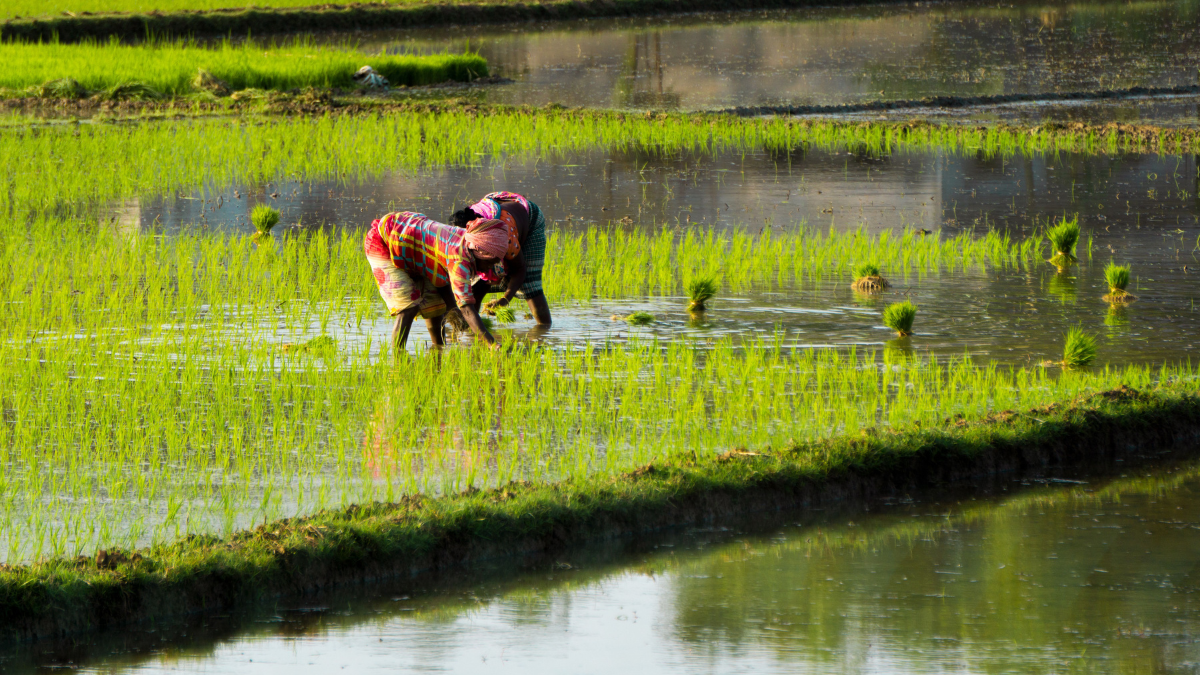
For generations, farmers in Kashmir have cultivated traditional varieties of rice adapted to the region’s distinctive growing conditions. A new genomic study has found that these varieties retain genetic characteristics associated with cold tolerance and local adaptation, potentially offering valuable resources for developing climate-resilient crops.
Researchers at the Sher-e-Kashmir University of Agricultural Sciences and Technology of Kashmir (SKUAST-Kashmir), Srinagar, analysed 142 rice germplasm samples to examine the genetic diversity and evolutionary history of rice cultivated in the region. Published in The Plant Genome in 2026, the study identified genetic signatures in traditional varieties that could help researchers develop rice better suited to environmental stress.
The findings are significant as climate change alters growing conditions and increases uncertainty for agricultural production. Preserving traditional crop varieties could give plant breeders access to genetic traits that may have become less common in modern cultivars.
Genes linked to cold tolerance
The study, titled Re-sequencing 142 rice genomes reveals the fine-scale population structure and phylogenetic affinities of landraces of Kashmir Valley: Evidence from domestication and adaptive signatures, used genomic analysis to investigate relationships among traditional landraces, modern varieties and other rice genetic resources.
The researchers found that Kashmir’s traditional varieties carried genetic signatures associated with temperate japonica rice, while many modern varieties showed stronger associations with indica lineages from subtropical India. This distinction points to differences in their genetic histories and adaptation to local growing environments.
Among the important findings was the identification of favourable variants of CTB4a and HAN1, two genes associated with cold tolerance in rice. The researchers also examined genetic variation linked to grain quality, plant development and other agricultural traits.
Traditional varieties, including Mushq Budji, Kamad, Kaw Kreer, Nun Beoul and Zag, displayed distinctive genetic patterns. Their diversity could provide useful material for future crop-improvement programmes.
The findings do not establish that all these varieties are more resilient than modern cultivars under every environmental condition. Instead, they identify genetic resources that warrant further investigation through breeding programmes and field trials.
Earlier research explains the significance
Previous research provides a scientific basis for investigating the cold-tolerance genes identified in Kashmir’s traditional rice varieties.
A 2017 study published in Nature Communications examined CTB4a, a gene associated with cold tolerance during the booting stage of rice development, when reproductive structures form. The researchers found that a favourable variant improved cold tolerance and helped maintain pollen fertility and seed setting under low-temperature conditions.
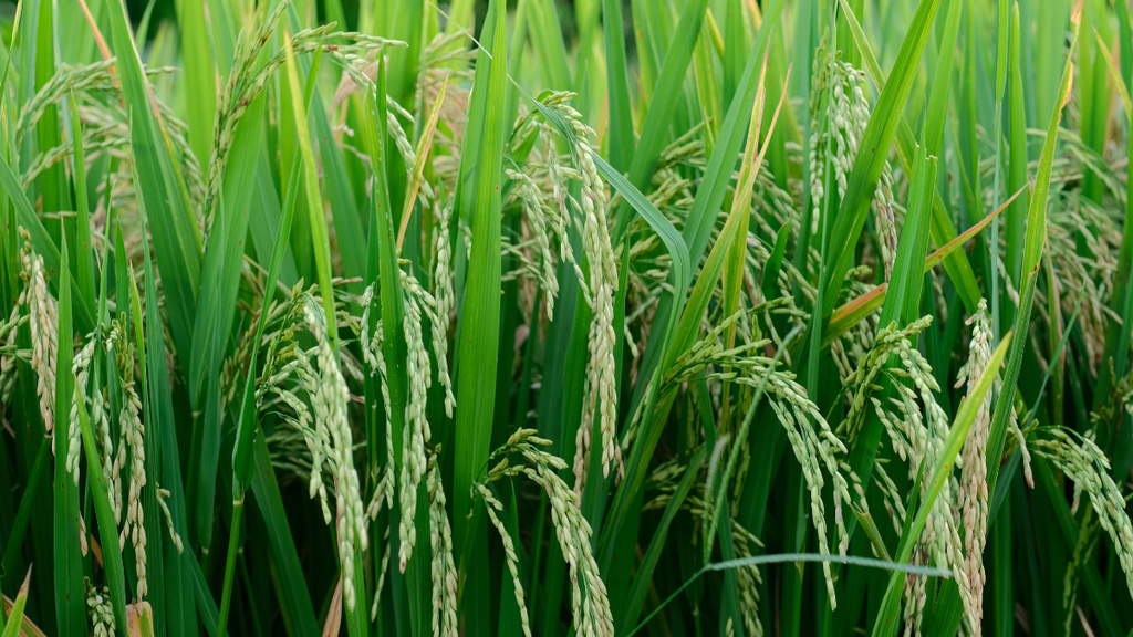
Crops in a paddy field.Image credit:Pexels
Similarly, a 2019 study published in the Proceedings of the National Academy of Sciences investigated HAN1 and found that natural genetic variation in the gene contributes to chilling tolerance in temperate japonica rice. The findings helped explain how rice adapted to cooler climates.
These studies strengthen the case for investigating CTB4a and HAN1 variants in Kashmir’s rice germplasm. However, the presence of promising genetic variants does not automatically guarantee improved performance in farmers’ fields. Their effects can depend on the crop’s broader genetic background, the timing and intensity of temperature stress, and other environmental conditions.
Conserving agricultural diversity
The Kashmir study also offers insights into the region’s agricultural history. Its genetic analysis suggests links between traditional Kashmir rice varieties and temperate rice lineages associated with Northeast Asia. The researchers propose that these lineages reached the region after approximately 1500 BCE, although this historical reconstruction remains an interpretation of genetic and archaeological evidence.
Beyond their historical significance, traditional rice varieties may preserve traits useful for future agricultural challenges. Modern breeding programmes often prioritise yield and other selected characteristics, but genetic diversity within traditional varieties can provide additional options for addressing environmental stress and maintaining grain quality.
The findings underline the importance of conserving traditional rice germplasm in gene banks and supporting its continued cultivation where feasible. Such conservation helps prevent potentially valuable genetic material from disappearing as farming systems and crop preferences change.
As climate change places increasing pressure on agricultural systems, Kashmir’s traditional rice varieties offer researchers a valuable starting point for investigating crop adaptation. Their genetic diversity connects generations of farming knowledge with modern genomic research, potentially helping plant breeders develop rice varieties suited to changing environmental conditions while preserving the region’s agricultural heritage.
Earth
India’s Green Cover Declined by 5.6 Percentage Points in 25 Years as Summer Heat Intensified: Study
A new study links India’s declining green cover to rising summer temperatures, highlighting the importance of vegetation conservation for climate adaptation.

India’s green cover declined from approximately 36.95 per cent in 2001 to 31.35 per cent in 2025, while non-green surfaces expanded across the country, according to a new study by Climate Trends. The analysis found that non-green landscapes consistently recorded higher summer temperatures than vegetated areas, highlighting the role of green cover in moderating local heat.
The study, Assessment of Green Cover Dynamics and Their Influence on Summer Temperature across India Using MODIS Land Cover and ERA5 Reanalysis Data, found that the average summer temperature difference between green and non-green landscapes ranged from approximately 1°C to 2.5°C. Areas experiencing green-cover loss recorded a mean summer temperature increase of 0.26°C.
The findings suggest that vegetation loss can contribute to local warming, although the study also identifies broader regional climate change as a factor influencing temperature trends. Protecting and restoring vegetation could help reduce local thermal stress, but it cannot independently offset the effects of global warming.
“Vegetation is not merely an ecological asset; it is an important component of India’s climate-adaptation infrastructure,” said Dr Palak Balyan, Research Lead at Climate Trends.
The study comes amid growing concerns over extreme heat and its implications for public health, livelihoods and infrastructure. The India Meteorological Department reported that 2024 was the country’s warmest year since records began in 1901, with the annual mean temperature 0.65°C above the 1991–2020 average.
Vegetation Loss and the Local Heat Effect
The Climate Trends analysis used land-cover information from the Moderate Resolution Imaging Spectroradiometer (MODIS) and ERA5-Land temperature data to assess changes between 2001 and 2025. It examined summer conditions during March, April and May to understand how land-cover transitions corresponded with temperature patterns.
Vegetation helps regulate surface temperatures through shading and evapotranspiration, the process by which plants release water vapour into the atmosphere. Trees reduce the amount of solar radiation reaching the ground, while vegetation and soil moisture influence how energy is absorbed and released. When green landscapes are replaced by built-up areas, exposed ground or sparsely vegetated surfaces, these cooling mechanisms may weaken.
Dr Balyan said the persistent temperature difference between green and non-green landscapes demonstrated the importance of vegetation in regulating local thermal conditions.
“Protecting existing natural vegetation should therefore be treated as an adaptation priority, particularly in regions experiencing simultaneous green-cover loss and rising summer temperatures,” she said.
The findings are consistent with the Intergovernmental Panel on Climate Change’s assessment of nature-based cooling measures, which identifies urban trees, vegetation and green infrastructure as potential ways to reduce heat exposure. However, the extent of cooling depends on local climate, vegetation type, water availability and the surrounding built environment.
Regional Differences Require Targeted Action
The study found that green-cover loss was concentrated in parts of western India, the Indo-Gangetic Plain, central India and the peninsula. Localised gains were identified in portions of the northeastern states, the Himalayan foothills and scattered areas of southern and eastern India.
Temperature changes also varied geographically. Warming was particularly evident across northwestern and northern India, while localised cooling occurred in parts of central and southern India. These variations indicate that national averages can obscure differences in local land-use patterns and climate conditions.
The findings have implications for urban planning, particularly in rapidly expanding cities where construction can replace trees, open spaces and other vegetated landscapes. Protecting mature trees, retaining existing green spaces and integrating vegetation into streets and public areas could help reduce heat exposure, particularly in vulnerable neighbourhoods.
However, restoration must be planned around local ecological conditions. Newly planted trees cannot immediately provide the shade offered by mature canopies, and their survival depends on suitable species, soil conditions, water availability and long-term maintenance. Protecting established vegetation is therefore an important complement to new planting initiatives.
Green Cover Cannot Replace Broader Climate Action
The study emphasises that land-cover changes are not the only drivers of summer temperatures. Both green and non-green landscapes experienced warming during the study period, indicating the continuing influence of broader climatic conditions.
Dr S K Dhaka, Professor of Atmospheric Physics at the University of Delhi, cautioned against treating vegetation restoration as a standalone solution.
“Vegetation restoration can reduce local thermal stress, but it should not be viewed as a substitute for broader climate action,” he said.
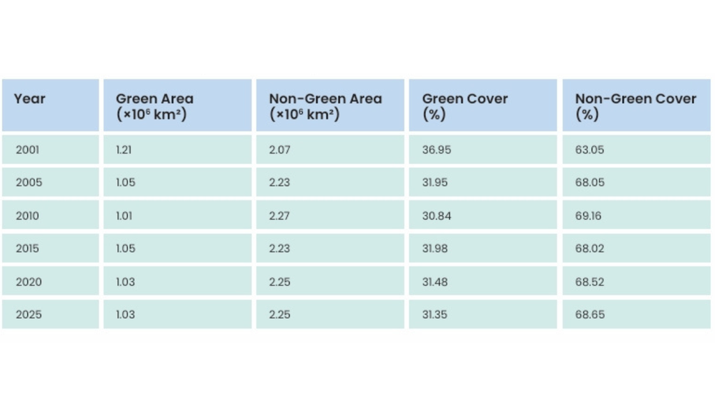
Temporal variation in green and non-green land cover across India
He added that warming observed even in areas that remained continuously green showed that large-scale climatic forces continued to influence regional temperatures.
“India therefore needs a dual strategy: prevent further loss of established vegetation while implementing scientifically targeted restoration in heat-vulnerable regions, alongside stronger action on water management, urban planning and greenhouse-gas emissions,” Dr Dhaka said.
The distinction is important because increasing vegetation alone cannot eliminate heat risks associated with rising background temperatures. Effective adaptation requires combining nature-based measures with emissions reduction, appropriate urban design and improved water management.
Aarti Khosla, Founder-Director of Climate Trends, said the study highlighted the practical consequences of losing vegetation.
“The study puts a number on something we’ve long argued, that vegetation is not a biodiversity afterthought, but a climate-adaptation infrastructure,” she said.
“Where green cover has disappeared, temperatures have risen with it, and that is a cost India’s communities are already paying for,” Khosla added.
She also pointed to international biodiversity commitments, including the target of restoring 30 per cent of degraded ecosystems by 2030, arguing that the gap between commitments and implementation has consequences for climate resilience.
The study recommends protecting existing vegetation, preventing avoidable green-cover loss and promoting ecological restoration as part of sustainable land management.
Its central message is that green cover should be considered more than an environmental amenity. While vegetation cannot prevent all forms of warming, conserving it can help moderate local temperatures and reduce thermal stress. As India faces increasing heat risks, integrating vegetation protection into climate adaptation and development planning could help build more resilient communities.


MIT Researchers Develop Origami-Based Method for Lightweight, Load-Bearing Structures

96% of the World’s Coral Reef Ecosystems Face Collapse Risk by 2075, IUCN Warns

India’s Electronics Boom Masks a Deeper Dependence on Semiconductor Imports

Project Cheetah: A Young Big Cat Killed by Gunfire Outside Kuno National Park

Cyclone Arnab Makes Landfall in Andhra Pradesh, Uproots Trees and Disrupts Power Supply

Knowing When to Think for Ourselves: AI, Intuition and the Education of Discernment

After a Scorching Summer, Delhi’s Children Are Slow to Return Outdoors

Two Chemists Win Nobel Prize for Solving a Century-Old Puzzle: Why Life Picks One Hand Over the Other

Marshall Islands: Why the US Nuclear Legacy Is Back Before the UN

How Wind Turbines Could Produce More Power From the Same Wind

-

 Math3 months ago
The 2026 Fields Medals: Four Proofs, Four Decades-Old Problems Solved
-
EP Deep Dive: Data & Solutions3 months ago
After Kerala’s Deadliest Landslide, the Hardest Thing to Rebuild Was Childhood
-
EP Deep Dive: Data & Solutions4 months ago
West Asia Crisis: Can Kerala’s Returning Gulf Migrants Find a Future in the Green Economy?
-
Space & Physics5 months ago
India Semiconductor Mission: ‘It’s Not About Fabs. It’s About Building An Entire Ecosystem’
-
Interviews1 month ago
From Scams to Screens: How the National Stock Exchange Rewrote India’s Equity Story
-
Climate5 months ago
The Climate World Cup? How Climate Change Could Affect Player Performance at the 2026 World Cup
-
Society4 months ago
What Is Civilisational Diplomacy? Understanding India’s Newest Foreign Policy Tool
-
Society4 months ago
From Bell Labs to the Classroom: A Second Career in Teaching